WELLS Database BC
British Columbia Ministry of Environment
Groundwater Resources and Tools

WELLS DATABASE BC
WELLS Database BC an online water well search tool and resource for provincial water well resources. WELLS Database BC is maintained by BC Ministry of Environment.
Groundwater Wells and Aqufiers
Explore the WELLS Database BC and search for technical data, information, and resources that help in planning and the safeguarding of our provincial water resources.
British Columbia Water Well Regulations
Locate local water well information, groundwater resources, aquifers, local well drilling, well drilling costs, water testing, local well pumps, and repair companies. Water well protection resources and Health Link BC water systems information.
WELLS Database BC Water Well Records
The official WELLS Database BC for registered water wells, groundwater, and aquifer data for the province allows public to search for information about an individual water well. Search or upload data to the WELLS Database BC.
The BC Water Resource Atlas and the WELL Database BC user guide provide a detailed explanation of how to locate data for registered water wells.
Registering an existing water well is not a legal requirement, it's done on a voluntary basis, As a result, not all water wells in British Columbia will be located in the database system.
How to Search WELLS Database BC
There are several possible approaches when searching the database for relevant information on an individual water well. Utilize Report #1 or Report #7 if you currently have a Water Well Identification Plate Number or a Well Tag Number. Use Report #2 if you just have access to basic information or facts with reference to a certain water well, such as the legal description of a property.
Legal Disclaimer
The province does not take any responsibility or obligation for the accuracy of data supplied. In no way should the provincial WELLS Database BC details provided be used as grounds for making any financial or any other commitments.
If you are purchasing real estate with a water well, it’s also important that you do your due diligence and NOT rely on the data provided by the Ministry of Environment (WELLS Data BC).
The WELLS Database BC is simply a resource and not to be deemed as legal documentation.
WELLS Database BC
British Columbia Ministry of Environment
Search Ministry of Environment WELLS Database BC
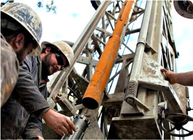
The Ministry of Environment water WELLS database BC is often used to search for local water well drilling records within British Columbia.
Local well drilling records or well logs may be located in the system by using legal descriptions, well locations, or construction details of a registered local drilled water well.
Local well drilling records or well logs may be located in the system by using legal descriptions, well locations, or construction details of a registered local drilled water well.
|
Water Well British Columbia
Ministry of Environment Water Well Protection Kit Click Here Groundwater Protection Regulations British Columbia Water Well Regulations Click Here Health Link BC: Water Well Water Well Health Regulations Fraser Health Click Here |
Canadian Drinking Water Guidelines
Complete Drinking Water Guidelines for BC - Health Canada Click Here Water Well Costs in BC Water Well Cost of Drilling a Well Water Well Cost BC Water Finder Colleen Roberts - Ground Water Consultant Click Here |
|

|
|
British Columbia
Land & Resource Data
Fraser Valley Water Well Resources
Users of the data warehouse who have experience using Geographic Information Systems (GIS) and advanced mapping applications may also refer to the following services.
MOE Discover Data Service
Ministry of Environment Discovery Service allows users to determine what data is available online for the Fraser Valley in the Province of British Columbia Land Resource Data warehouse including Abbotsford, Chilliwack, Clearbrook, Harrison Lake, Hope, Ladner, Langley, Maple Ridge, Mission, Pitt Meadows, Richmond, Surrey, Tsawwassen, and White Rock.
The available layers include water well, aquifers, and other spatial data sets for the area..
The available layers include water well, aquifers, and other spatial data sets for the area..
Water Well Fraser Valley Data Download
The MOE Distribution Service allows users of the system to order information for download directly from the warehouse to their own computers.
The available data layers can be determined using the Discover Data Service as explained. The user may select features from a data layer of interest for a specific geographic area and export the data in several formats.
There's generally not a cost associated with local water well data acquisition. Not all British Columbia Ministry of Environment data layers are available to members of the public including residents of the Fraser Valley.
iMap BC Application for Fraser Valley
This is an online mapping system for water wells in Fraser Valley, it is similar to the British Columbia Water Resources Atlas as described above.
Using the Spatial Overlay Engine (SOE) tools it is possible to select records for multiple water wells in Fraser Valley or other areas in the province and export them in various downloadable formats (including as spreadsheet or (CSV) comma delimited files.
Using the Spatial Overlay Engine (SOE) tools it is possible to select records for multiple water wells in Fraser Valley or other areas in the province and export them in various downloadable formats (including as spreadsheet or (CSV) comma delimited files.
British Columbia Ministry of Environment Regulations:
Water Well Setback Regulations for Fraser Valley
In the Fraser Valley New Wells Should Not Be:
1) Within a horizontal distance of 3 m (10') of an existing building;
2) Within a horizontal distance of 30 m (100') of any probable source of contamination or point of waste discharge to the ground, such as a privy vault, cesspool, septic effluent field, manure heap, stable or pig sty; or
3) Within a horizontal distance of 120 m (400') of any cemetery or dumping ground.
Not all water wells are drilled deep in the Fraser Valley, many wells may be less than 200' in depth and if located near possible sources of contamination, a well can become contaminated and possibly cause serious illness.
The regulated BC Ministry of Environment water well set-backs are in place to protect water wells from becoming contaminated from many possible sources.
For comparable water well drilling depths in your neighbourhood and Ministry of Environment set-backs, please refer to all local resources, including well drilling reports, Resources are available at British Columbia Water Well Search.
Some potential sources of water well contamination include waste discharge to the ground, such as a privy vault (also known as an outhouse or pit toilet), cesspool (“overflow” pits), underground storage tanks, septic tanks, an effluent field, stable or pig sty, manure heap, fertilizers and pesticides, runoff from urban areas, a cemetery or landfill sites.
A water well drilled in the Fraser Valley should be located on higher ground when possible to protect the well head from normal or seasonal flooding and possible surface drainage.
Shallow wells and deep wells in the Fraser Valley may be vulnerable and should always be located away from surface drainage ditches and other potential sources of contamination.
Fraser Valley Water Well Groundwater Regulations & Local Bylaws
Water Wells Regulations City of Chilliwack Groundwater Protection
Well Drilling Regulations Chilliwack - Environment Groundwater & Bylaws
Well Drilling Regulations Yarrow - Environment Groundwater & Bylaws
Well Drilling Regulations Sardis - Environment Groundwater & Bylaws
Well Drilling Regulations Harrison Lake - Environment Groundwater & Bylaws
Well Drilling Regulations Hope - Environment Groundwater & Bylaws
Well Drilling Regulations Abbotsford - Environment Groundwater & Bylaws
Well Drilling Regulations Clearbrook - Environment Groundwater & Bylaws
Well Drilling Regulations Langley - Environment Groundwater & Bylaws
Well Drilling Regulations Fort Langley - Environment Groundwater & Bylaws
Well Drilling Regulations Aldergrove - Environment Groundwater & Bylaws
Well Drilling Regulations Cloverdale - Environment Groundwater & Bylaws
Well Drilling Regulations Maple Ridge - Environment Groundwater & Bylaws
Well Drilling Regulations Pitt Meadows - Environment Groundwater & Bylaws
Well Drilling Regulations Whonnock - Environment Groundwater & Bylaws
Well Drilling Regulations Ruskin - Environment Groundwater & Bylaws
Well Drilling Regulations Mission - Environment Groundwater & Bylaws
Well Drilling Regulations Lake Errock - Environment Groundwater & Bylaws
Well Drilling Regulations Delta - Ladner - Environment Groundwater & Bylaws
Well Drilling Regulations Tsawwassen - Environment Groundwater & Bylaws
Well Drilling Regulations White Rock - Environment Groundwater & Bylaws
Well Drilling Regulations Richmond - Environment Groundwater & Bylaws
Well Drilling Regulations Burnaby - Environment Groundwater & Bylaws
Well Drilling Regulations Surrey - Environment Groundwater & Bylaws
Well Drilling Regulations Lions Bay - Environment Groundwater & Bylaws
Well Drilling Regulations Squamish - Environment Groundwater & Bylaws
Well Drilling Regulations Whistler - Environment Groundwater & Bylaws
FRASER VALLEY WELL DRILLING SERVING:
Fraser Valley Water Well Service Area Includes: Abbotsford | Chilliwack | Yarrow | Sardis | Clearbrook | Harrison Lake | Hope | Ladner| Langley |
Fort Langley | Aldergrove | Cloverdale | Maple Ridge | Whonnock | Ruskin | Pitt Meadows | Mission | Dewdney Area | Coquitlam | Burnaby | Surrey | Tsawwassen | White Rock | Squamish | Whistler | Pemberton
Well Drilling Fraser Valley
Phone: 604-670-3033
Well Drilling Fraser Valley